
Not island fine.
“OK. Line them up and tell them we’ll be waiting for our dinner tributes at the rear of the vessel.”©
You’ve been there.
All it takes is rolling over and waking up on the wrong side, then nothing goes right.
And snarky people say things like “Well, what did you expect? You should have known.”
Bolivar Peninsula couldn’t rollover and pass out of the way of Hurricane Ike a few years ago. FEMA pictures pretty much tell the tale.

Proof you can build a hurricane proof house if you try. Yellow house sole surviving structure of 2008 Hurricane Ike/Gilchrist, TX.(USPD/Commmons.wikimedia.org)
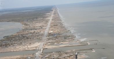
Wider view of the narrow Bolivar Peninsula devastated by the storm.The peninsula is about 27 miles long, maybe 3 miles wide at the widest point. (USPD/Commons.wikimedia.org)

To get you oriented: Bolivar was on the east/worst/dirty side of the rotating hurricane that hit the Texas coast. Bacliff and San Leon, across the Bay on the mainland, also looked like a war zone while the only damage our house (on left edge of the map middle) was a dented gutter from a neighbor’s unsecured board. The main part of Houston is located off the top left corner of this map. Newcomers: please do not evacuate Houston if a storm comes: You are not on the coast, you are on higher ground, and there are no dikes around Houston to fail, so please don’t clog the highways leaving out of fear.(USPD/Commons.wikimedia.org)
Finding yet another reason to avoid work, we recently decided to check on Bolivar, a trip that is fastest by going to Galveston Island, then taking the Bolivar Ferry to the Peninsula.
Although they run as many as 4 ferries during peak times, the lines can be long with a wait of over two hours – unless you are a Bolivar resident or doctor with a pass or a medical emergency and eligible for the fast lane. (Galveston is the big regional hospital and medical school). Mid week is the time for a rare uncrowded ferry trip across. It’s only a 3 mile ride across.
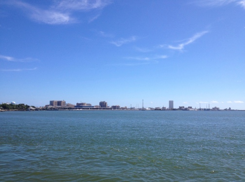
On the ferry looking back to Galveston Island’s bay side. Left of center is the Regional Medical Center/UTMB Medical School (1891) whose research labs contain samples of the very worst viruses/infectious diseases in the world. Next to the Medical Center complex are the wharfs, cruise ship docks, and ship yard.(image:©)
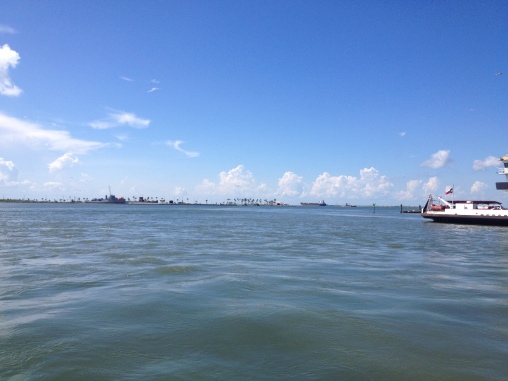
On the way across Galveston Bay to Bolivar. Incoming ferry on right. Squint at the horizon to see Seawolf Park on Pelican Island with its’ destroyer escort, submarine, and the WWI SS Selma, the largest concrete tanker ever built. Pelican Island was once an immigration entry station. Past the park, a tanker heads into the Ship Channel.(image ©)

A ferry headed to Galveston dock past a tanker with tug boat beside it. This is not an anchorage and unclear why the tanker is sitting there unless disabled. Not an anchorage. Probably empty since the red part on the hull would be under water if loaded. (Image: ©)

Point Bolivar Lighthouse on Bolivar Peninsula, TX. Built in 1872, it’s red brick covered with riveted iron plates and used to be painted with black and white bands. During the 1900 Storm that destroyed Galveston, 125 people sheltered inside this lighthouse and all survived. At one point the strong winds made the structure sway so much that the mechanical parts of the rotating light stopped working. The lighthouse keeper rotated the light by hand the rest of the storm. During the 1915 hurricane, also a devastating one with measured winds of 126 mph, 61 people survived the storm by sheltering there. A 11 foot storm surge broke open the bottom doors and washed away the tanks on the lower level that held the oil for the lamps. The light was dark for two days. In 1918 two cottages on stilts were built for the keeper, his assistant, and their families. Another lighthouse was built in a different location and this one was eventually sold by the government as surplus to the Boyt family (1950-ish). While it remains in the family’s hands and off-limits to the public, it and the cottages are seen in movies. The lamps and the reflector lens were removed and reassembled in the Galveston County Museum. Read more stories about the lighthouse and current owners here (Image:©)
Saying that Bolivar is quirky, eccentric, and often rowdy is an understatement.
The cattle are back grazing in the peninsula’s coastal pastures amid shoulder-tall brush and wetlands.
Birds stand their ground on the roads and question your right to be there.
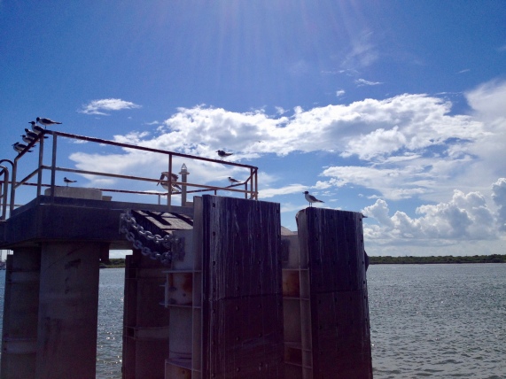
Fishermen line the jetties.
Colorful new beach houses line up like flocks of square seagulls along the sandy shore which is well known for wild spring breakers, weekend brawls, beaches you can still drive your car on, and lots rental beach houses.
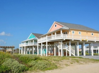
New beach houses. Owning a beach house sounds wonderful until memories of September storms surface. Maybe beach houses are like horses: best if your neighbor has one and is willing to share.(boliverpeninsulatexas.com)
The Peninsula, named for the South American hero, Simón Bolívar, has a history is just as colorful as the new houses:
Shipwrecks, explorers, smugglers, pirates holding huge parties in the groves of giant oak trees, Native American and ancient burial grounds (and the state’s desperate efforts to keep people from carrying off early artifacts), the Audubon Society’s Bird Sanctuary, not to mention the recent bitter fight over Rollover Pass between the state, fishermen, and land owners (The pass originally got the name as ship captains/smugglers slipped goods past Galveston’s customs stations during Spanish rule and later during Prohibition. Barrels and goods – exports and imports – were secretly rolled across the narrow land to the transportation waiting on the opposite side.)
All that for another post…when it’s cooler and less crowded.
Meanwhile, view Bolivar’s webcams here.
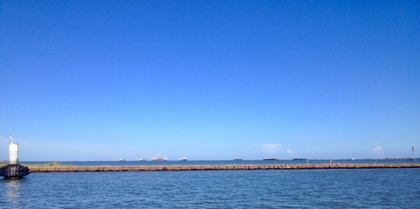
On the ferry returning to Galveston. We did see the local dolphins dancing along side not far from here. Bolivar’s rock jetty is a favorite with fishermen. Behind them are tankers waiting in the gulf’s anchorage before entering Ship Channel to Houston’s port. (Image ©)
Yep, not even August and the heat is on here: 103 – 107 F. heat index. Good news and bad news:
Forecasters say that the huge plumes of fine Saharan dust blowing westward across Atlantic Ocean and the Gulf prevents tropical storm development.
So despite the extreme heat and the very warm waters, smooth sailing here so far. (But please pass the eye wash and tissues. I prefer my sand under a beach towel.)
Rollin’ over with waves from the sands
Phil, the Philosopher Mouse of the Hedge
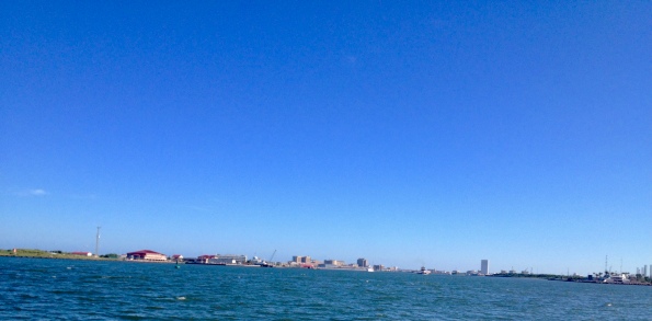
Galveston’s bay side as seen from ferry. Buildings left to right: Coast Guard Station, UTMB Medical in center, right is Seawolf Park – and at the far right edge is a large number of jack up oil rigs waiting for refurbishing or to be towed out to a job site in the Gulf of Mexico. Oh, squint and you’ll see it all. I’m more into actually being there than walking around with a camera stuck in front of my face and struggling to get perfect pictures HAHA! (Image:©)
Discover more from Philosopher Mouse of the Hedge
Subscribe to get the latest posts to your email.


I always wanted to live in a lighthouse… now I know that was not just a silly idea… I feel sorry for the people of this island… impossible for us europeans to imagine a storm what can blow houses away (apart from dorothy’s crib)
LikeLiked by 2 people
Light houses are like human made trees with steps for easier climbing. Living in one would be like living in a movie…but better on on land than out in the water where you have to row ashore for every little thing. Even in the Bolivar lighthouse, one early wife said they we’re so isolate with little traffic, but they read books a lot. Peace and quiet and time is a luxury now.
Realistically, the area had many many old old patched together wood frame beach places that didn’t stand much chance against a 10 foot storm surge. Even old houses built on low stilts had problems as the house just floated off on the surge water like a raft – and then played bumper cars. The house that remained was constructed with roof, walls, floor and all strongly tied/bolted together from top to bottom and it was up really high – so it kept its’ roof, the structure stayed on its’ legs. New regulations are required for building in lots of places that face floods or coastal storms now – so all the new houses are taller and more sturdy. No guarantee, but will probably survive. (Tornadoes damage not included or travel insurance to OZ). Construction costs more which means houses may be small/more compact, but cheaper in the long run if you look at the pictures. We’re inland, but close enough that being in neighborhood built to Florida Storm Standards was important to us…so we happily settle for smaller house on a little hill, well, you wouldn’t call it much of a hill, more of a rise, but every inch counts. HAHA
Thanks for dog paddling over to chat
LikeLiked by 1 person
Such devastation! I vote for going into the lighthouse when the weather gets really bad. Can’t imagine turning the light by hand all those hours, but I guess that’s why lighthouse keepers make the big bucks, right? I, too, prefer my sand on the beach, under a towel and under me. But what are you gonna do? Thanks for keeping the triple digits down south. I’m enjoying having the windows open this morning, although they’ll get closed later.
janet
LikeLike
It looks bad- it was bad. Still, some of those houses and structures were very very old and others were built before hurricane building standard/construction practices became more common. Can’t expect a ground level structure or wobbly one on marginal stilts that weren’t all that high to survive an 10+ storm surge with hurricane winds. What will tell the tale is what’s sitting fine after the next storm. (Can’t imagine what their insurance costs must be now)
A good rain would get those sand particles of our the air and onto the beach/soil where it can do some good. Nature does recycle, too.
Thanks for surfing in with a comment
LikeLike
You have me packing my bags to relocate until you mentioned the Saharan Dust! There’s always something, isn’t there. Beautiful though. Currently looking for a friend with a beach house.
LikeLike
This dust. A day ago the sky/air was hazy grey and felt really heavy. Last night it started breaking ups so the sunset started having some gold and reds again, so it’s getting better.The NASA tracking shows how much of the US is covered by these plumes. (Great. We get the Mexican burning of the fields smoke in spring and desert dust in summer…you can see why we eagerly wait for fall’s strong north winds.)
Be careful with your landscape projects with all the summer heat…hmm, stuck inside time great for reconnecting with old friends with beach houses, right? HAHA
Thanks fort breezing by
LikeLiked by 1 person
We’re inland, so no hurricanes. Just tornadoes. And strong storms.
LikeLiked by 1 person
Enough of a rain storm and any place can look like water front property. Whew, Arizona right now with those flash floods.
Sometimes ponding on the road sounds like the perfect amount of moisture.
Thanks for paddling along
LikeLiked by 1 person
I did not realize that the haze in our Oklahoma skies were Saharan dust until I saw something on the news last night. I wonder how far north that will drift?
The only hurricane adventure I’ve been on was on our way back to port after a Caribbean cruise. Katrina was on our heels and it was mighty worrisome! We had to head back a day early, and the seas were rough. They had hurl bags taped everywhere around the ship, and I did well overall, but I felt as if I had a dull hangover the whole trip back. And sleeping at night was impossible with the ship listing… one had to hang onto the sheets for fear of rolling out of the bed.
We do love the beach though. We haven’t been in a very long time…
LikeLike
I bet is was a rough trip. Whew. Sleeping on a boat/ship is a whole different experience. End of summer/fall is sometimes a risky time for cruises.
Views from space give us so much more information – and things to wonder about now. A bit less dusty today. Hope things have cleared there.
Thanks for swooping by with a comment
LikeLike
We visited in January of this year when we were in the Galveston area. Thank you for filling in the holes of our history knowledge about the Peninsula–it makes me want to visit again more in depth the next time we are there. Dawn
LikeLike
The land as well as all the different waves of people and cultures that washed up here do provide lots to discover and explore. Gulf coastal area never bland in flavor. Thanks for traveling along
LikeLiked by 1 person
My parents are headed down that way this winter – I’ll have to let them know, so they can drop by for a visit (and a drive along the beach).
LikeLike
Boliver has a habitat/perserve area there, too. Tell them to ride the ferry across to Galveston. East beach has a great park and new nature preserve/wetlands loaded with winter birds. Does the road on West Beach there’s a large state park with facilities, parking, camping, and more birds in the wetlands. Some places you can still drive along the beach on the island…just watch the incoming tide levels.
Thanks for strolling along the sands.
LikeLiked by 1 person
Oh, they would definitely enjoy the habitat/preserve area – I will let them know!
LikeLike
Some of our favorite places!
LikeLiked by 1 person
Just looking at the photo’s I’d say that if hurricanes don’t do for it, rising ocean levels will. But wait, climate change is a myth, isn’t it?
LikeLike
It’s a flat barrier coastal area all right. Wetlands are critical for filtration as well as habitat (and there’s a nice big protected one there now.)
Actually originally the ocean covered most of Texas. You can find fossils of shells and sea creatures in the Dallas and Austin areas. Fun, right? And the smarties think they have discovered something and have it figured out. Constant change; nothing new. Things just going back to what once was. Always some people who want to make others worry and stress. People act like humans are the ultimate species instead of having a shelf life like the others.
Now I’ll be really intrigued to see if the drifting continents rumble and shake themselves back together. “One World” becoming reality! HAHA
Thanks for wading in with a comment
LikeLiked by 1 person
That’s fascinating about Texas once being under the sea. I can hear some mean-spirited souls muttering, best place for it…I’m not one. I only know one girl from Texas and I like her 🙂
LikeLike
Water is life.
Not just Texas. (one map here. http://www.nhnct.org/geology/geohist.html ) The seas are the beginning of the oil/gas fields. Geology is really fascinating. A serious way to dig history HAHA
LikeLike
Ouch!
LikeLike
For a long time water wings were standard issue? 🙂
LikeLike
Not chicken wings?
LikeLike
Shh. The dinosaurs are a tad sensitive about how closely related they are to the current winged cousins…
LikeLike
They must hate Colonel Sanders.
LikeLike
Being creatures of bigger views, they overlook small petty things…even if that glaring white suit is sooo difficult to ignore….the stomping instinct is strong….
LikeLike
They can stomp away as far as I’m concerned.
LikeLike
Oh, you know how it is: can’t rush in all the time with the little ones or they never learn to peck things out for themselves.
LikeLike
Thus spake the great white chicken 🙂
LikeLike
Who commands the great plate in the sky (And some call them aliens while plenty of weird unkowns sitting around here HAHA)
LikeLike
Exactly. Who needs the two-headed, green-skinned brigade when we have enough weirdos to populate the universe right here!
LikeLike
Exactly.
LikeLike
🙂
LikeLike
Lighthouses are fascinating. This one looks like it really is something from a different era– which adds to its quirkiness. I never think of TX as having lighthouses, only the Carolinas. That’s because so many people from this area retire to HIlton Head– hence that’s what I hear about.
LikeLike
While you keep your eye peeled for hurricanes, we keep ours peeled for forest fires. Each to his own, I guess. Don’t know which is more devastating but you can fight back more effectively with fires. Thanks for the tour and insights, Phil. –Curt
LikeLike
Just the other side of Houston they are fighting a big prairie fire – every time they think it’s out, well, you know how it goes. There’s a disaster designed for every place…hmmm. Think that’s coincidence or is there a message there? More likely writer Thomas Hardy is right: nature/the environment is completely unconcerned, oblivious, totally neutral towards humans, it just seems like a vendetta sometimes. He was one who seemed to feel those who live in harmony with nature are happier/more content. Works for me.
Keep an eye on the flames. Thanks for kicking around in the sand here
LikeLike
There may be some messages, Phil, like when we create situations that lead to the disasters. But beyond that, I’m with you. As a whole, nature is not vindictive. At least I hope not. Or we could be in a heap of trouble. 🙂
LikeLike
When lightening strikes a pile of tires like yesterday near Dallas, you have to wonder. Nobody like litter blight. HA HA
LikeLike
Laughing. That will show them. BTW, I’ve been reading a fascinating article by John McFee in his book. “Irons in the Fire” about tire waste. –Curt
LikeLike
What a great day you had — and look at those blue skies. You’re right — it’s about time for that dust to get out of here, and it does seem as though it’s going. It’s going to be interesting to see what happens when Rollover Pass gets closed. They swear it’s not going to affect the bays, but I just can’t believe that. After all — that’s why they opened it in the first place: the increase the health of the bay system. Ah, well. I’m sure the politicians can figure it all out, as soon as they stop throwing spitwads at each other. Actually, spitwads would be a step up. I wasn’t exactly pleased when I got home from work tonight and found out how our national leaders had been spending their day. They need Ralphie’s mother, and her bar of soap. Sigh.
LikeLike
So nice to get out – would have been better if not roasting – but a change of view anyway. Interested to see how the rebuild is going. (Lots of new houses perched very close together – and a huge number with beach rental signs. The bay /intercoastal side much more quiet.). We only saw 3 dolphins.(But no line or wait!). Heat not stopping the fishermen, though.
Guess the alligators are going to have to gut it up and stomp across land/road in order to get to their skin-soothing spa once the pass is closed. What a stupid idea…but then again there’s a lot of stupid going around right now. I’d say send them to their rooms, but their digs are far too luxurious and it would be just another excuse to ignore there work that needs to be done.
Thanks for checking to see what is washing up
LikeLike
Great post! Haven’t been there in years.
LikeLike
It’s really changed as far a the buildings, but it’s still Bolivar in attitude. Thanks for shuffling along these sands
LikeLike
Having lived in cyclone (hurricane) prone parts of Australia I find it a bit incongruous the design of the houses you have pictured.
They all seem to be built on stilts constructed in timber, seems that they are asking to be picked up and blown away
Theres a very strict building code here since the devastation Cyclone Tracy of ’74 that took many lives
LikeLike
Regional architecture and building practices are always fascinating
Bolivar Peninsula is mainly an economical recreation area with weekend homes, vacation rentals, beaches with bait stores, bars and restaurants. Although there are small communities, a small schools, fire stations and realtors, it’s too far for most to commute to jobs inland or across in Galveston ( also a resort area but with a medical school and regional med center.) As people realized anything you build there is like to eventually flood or get storm damage, many house, cabins, camp houses were pretty old and patched together. Most people there just didn’t;’t put much money in these beach places.
Recently the feds used satellite data to determine elevation/flood risks and it’s made a difference – on construction and cost. FEMA/coastal areas have firm guidelines of what can be built and how it can be constructed. If you don’t comply with the standards, you cannot get wind, flood insurance from state/fed pool, many insurance companies will not cover you, and you may not be able to get a loan to build/buy. If your home is damaged more than a certain % of it’s worth, you cannot get permits to rebuild/repair unless you fix your whole structure to conform. Makes sense. Florida Hurricane standards were developed about the same time as yours
The pilings make sense as most of the time, it’s just high tides in that area. I think the current standards 12-16 feet depending on location/elevation of land. The first floor cannot have “permanent construction” (like bedrooms, bathrooms…) and must have break out panel or louvers if enclosed to allow flood water to flow through – so you see most people leave that space open for shade or parking cars. The pillars can be wood or concrete but both are pounded far into the ground probably 2-3 times what you see above – depending on how far below the solid footing/rock base is. Some insurance companies do not insure houses with wood pillars as termite can eat it and endanger the structure above. Many feel that wood will sway and bend and protect the structure it supports by having some flexibility. Pier and beam construction does make it easier to level a house if it settles in this goopy gumbo soil.
Siding is usually concrete board. If you noticed the only house that survive, that’s the one built to hurricane standards – which means there are metal straps/extra tie-together boards from top of roof to bottom all inside the structure. The whole thing is tied together as a unit and the unit is firmly anchored to the supporting pillars. Bolts are used in place of nails. It’s quite complex and it all has to be inspected and meet guidelines.
Even though we are inland by the lake (which flows into Galveston Bay and the ship channel, we cannot get a new roof without the windstorm inspectors/FEMA approving materials and inspecting it. (If we want to insure it)Worth the effort when you consider the alternative.
Construction and engineering really interests me. Maybe in another life time….
Thanks for building such a cool comment
LikeLiked by 1 person